Alaska National Parks Map
Alaska is home to some of the most breathtaking and pristine national parks in the United States. It has 8 National Parks. These parks showcase the state’s diverse landscapes, rich wildlife, and stunning natural beauty. Here are some of the notable national parks in Alaska:
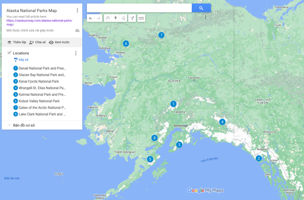
Alaska National Parks Map 2024
I also add Alaska National Parks Map on Google Map at the end of the article.
1. Denali National Park and Preserve
- Location: Denali National Park is located in the interior of Alaska, approximately 240 miles north of Anchorage.
- Size: The park covers over 6 million acres, and it is home to North America’s highest peak, Denali, which stands at 20,310 feet.
- Established: Denali National Park was established in 1917 as Mount McKinley National Park and later renamed Denali National Park in 1980.
- Wildlife: The park is rich in wildlife, including grizzly bears, wolves, moose, caribou, Dall sheep, and a variety of bird species.
- Visitation: Visitors can explore the park by bus or private vehicle on the park road, but much of the interior is only accessible by foot or air.
- Weather: Denali National Park experiences a subarctic climate with long, cold winters and short, mild summers. Winter temperatures can drop well below freezing, and snowfall is common. Summer temperatures typically range from 40°F to 70°F (4°C to 21°C), making it the most popular time to visit.
2. Glacier Bay National Park and Preserve
- Location: Glacier Bay National Park is located in Southeast Alaska, near the town of Gustavus. The park is part of the larger Glacier Bay and Tatshenshini-Alsek Wilderness Park, a UNESCO World Heritage Site.
- Size: The park covers over 3.3 million acres and includes fjords, glaciers, mountains, and coastal ecosystems.
- Established: Glacier Bay National Park was established as a national monument in 1925 and designated as a national park and preserve in 1980.
- Glaciers: The park is known for its impressive tidewater glaciers, including the Margerie Glacier and the Grand Pacific Glacier.
- Weather: The climate in Glacier Bay is characterized by cool, wet weather with a maritime influence. Summer temperatures typically range from 45°F to 65°F (7°C to 18°C). Rain is common throughout the year, so visitors should be prepared for wet conditions.
3. Kenai Fjords National Park
- Location: Kenai Fjords National Park is located on the Kenai Peninsula in south-central Alaska.
- Size: The park covers over 669,984 acres and is known for its stunning fjords, glaciers, and coastal ecosystems.
- Established: The park was established in 1980.
- Weather:The park experiences a maritime climate with cool temperatures and a high level of precipitation. Summer temperatures typically range from 40°F to 60°F (4°C to 15°C).
- Hiking: There are several hiking trails in the park, ranging from short walks to more challenging hikes. These trails offer opportunities for wildlife viewing and panoramic views.
- Wildlife Viewing: Kenai Fjords is home to a variety of wildlife, including sea otters, harbor seals, sea lions, whales, and numerous bird species. The park is also known for its large population of puffins.
4. Wrangell-St. Elias National Park and Preserve
- Location: Wrangell-St. Elias National Park and Preserve is located in south-central Alaska, near the town of Copper Center.
- Size: It is the largest national park in the United States, covering over 13 million acres.
- Established: The park was established in 1980, incorporating Wrangell-St. Elias National Monument, which was designated in 1978.
- Weather:The park experiences a subarctic climate with long, cold winters and relatively warm summers. Winter temperatures can drop significantly, with extreme cold being common. Summer temperatures typically range from 40°F to 70°F (4°C to 21°C).
- Hiking: There are numerous trails for hiking and backpacking, ranging from easy walks to challenging backcountry routes. The park’s vast and diverse landscapes offer a variety of hiking experiences.
- Wildlife: The park is home to diverse wildlife, including bears, moose, Dall sheep, caribou, and a variety of bird species.
5. Katmai National Park and Preserve
- Location: Wrangell-St. Elias National Park and Preserve is located in south-central Alaska, near the town of Copper Center.
- Size: It is the largest national park in the United States, covering over 13 million acres.
- Established: The park was established in 1980, incorporating Wrangell-St. Elias National Monument, which was designated in 1978.
- Weather:The park experiences a subarctic climate with long, cold winters and relatively warm summers. Winter temperatures can drop significantly, with extreme cold being common. Summer temperatures typically range from 40°F to 70°F (4°C to 21°C).
- Wildlife: Apart from brown bears, Katmai is home to a variety of wildlife, including moose, caribou, wolves, and marine life along the coast.
6. Kobuk Valley National Park
- Location: Kobuk Valley National Park is located in northwestern Alaska, above the Arctic Circle.
- Size: The park covers over 1.7 million acres, and it is known for its diverse ecosystems, including the Great Kobuk Sand Dunes.
- Established: The park was established in 1980.
- Weather: Kobuk Valley experiences an arctic climate with long, cold winters and short, cool summers. Winter temperatures can be extremely cold, dropping well below freezing, while summer temperatures range from 40°F to 70°F (4°C to 21°C).
7. Gates of the Arctic National Park and Preserve
- Location: Gates of the Arctic National Park and Preserve is located in the Arctic region of Alaska, entirely north of the Arctic Circle.
- Size: It is the northernmost national park in the United States and covers over 8.4 million acres, making it the second-largest national park in the country.
- Established: The park was established in 1980.
- Weather: Gates of the Arctic experiences an Arctic climate with extremely cold temperatures. Winters can be harsh, with temperatures well below freezing, while summers are short, with temperatures ranging from 30°F to 70°F (-1°C to 21°C).
8. Lake Clark National Park and Preserve
- Location: Lake Clark National Park and Preserve is located in south-central Alaska, southwest of Anchorage.
- Size: The park and preserve cover over 4 million acres, featuring diverse landscapes including mountains, glaciers, and coastlines.
- Established: Lake Clark National Park was designated a national monument in 1978 and became a national park and preserve in 1980.
- Weather:The park experiences a subarctic climate with cool temperatures. Summer temperatures typically range from 40°F to 70°F (4°C to 21°C), while winter temperatures can drop significantly below freezing.
- Wildlife Viewing: The park is home to diverse wildlife, including brown bears, moose, wolves, caribou, and numerous bird species. Redoubt Bay is particularly known for bear viewing.
- Fishing: Lake Clark and its rivers provide opportunities for fishing, with salmon being a common catch.
Alaska National Parks Map on Google Map
Tag: Alaska National Parks Map, national parks in alaska map, national parks alaska map, map of Alaska national parks, map of national parks in Alaska, Alaska National Parks Map on Google Map, list of national parks in Alaska, how many national parks in Alaska, alaska national parks list, national parks in Alaska list
Read more: