California National Parks Map
California National Parks Map 2024
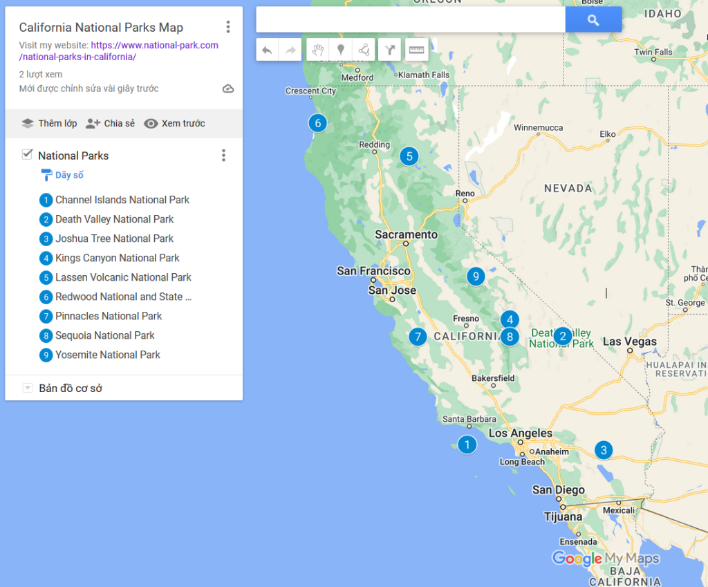
I also add California National Parks Map on Google Map at the end of the article.
1. Channel Islands National Park
Channel Islands National Park is located off the coast of Southern California. The park includes five islands: Anacapa, Santa Cruz, Santa Rosa, San Miguel, and Santa Barbara.
Access to the islands is primarily by boat or small aircraft. Boats depart from various mainland locations, including Ventura and Santa Barbara. Island Packers is a common ferry service provider.
The park offers a range of activities, including hiking, camping, snorkeling, diving, wildlife watching, and exploring cultural and historical sites.
The climate on the Channel Islands is influenced by the Pacific Ocean. It is generally mild, but conditions can vary between the islands. Summers are typically cooler than the mainland, and winters are mild.
2. Death Valley National Park
Death Valley National Park is located in Eastern California and extends into Nevada. It is the largest national park in the contiguous United States.
The park features diverse landscapes, including salt flats, sand dunes, badlands, canyons, and mountain ranges.
Death Valley is known for its extremely high temperatures, especially during the summer months. It holds the record for the highest air temperature ever recorded on Earth. Summers can be scorching, with daytime temperatures often exceeding 100°F (38°C) and sometimes reaching well over 120°F (49°C). Winters are milder, with daytime temperatures ranging from the 60s to 70s°F (15-25°C), but nighttime temperatures can still drop significantly.
3. Joshua Tree National Park
Joshua Tree National Park is located in southeastern California, near the cities of Twentynine Palms and Joshua Tree. The park is known for its unique desert landscapes and the Joshua Tree, a distinctive species of yucca plant.
There are several visitor centers in the park, including the Joshua Tree Visitor Center, Oasis Visitor Center, and Cottonwood Visitor Center. These centers provide information, maps, exhibits, and ranger-led programs.
The park experiences a desert climate, with temperatures varying significantly between day and night. Summers can be hot, with daytime temperatures often exceeding 100°F (38°C), while winters are generally mild, with daytime temperatures ranging from the 60s to 70s°F (15-25°C).
4. Kings Canyon National Park
Kings Canyon National Parks is located in the southern Sierra Nevada mountain range in eastern California. It is adjacent to Sequoia National Park, and the two parks are jointly administered.
The park is known for its rugged mountain scenery, deep canyons, and giant sequoia trees. Kings Canyon itself is one of the deepest canyons in North America.
Kings Canyon National Park is the second-oldest national park in the United States. It was established on 25 Sep 1890 to protect the Big Trees in Giant Forest, including the General Sherman Tree, the world’s largest living thing. Sequoia also contains the Mineral King Valley and Mt. Whitney, the highest mountain in the U.S. outside of Alaska.
Weather conditions can vary with the seasons. Summers are generally warm, with daytime temperatures ranging from 60°F to 90°F (15°C to 32°C). Winters can be cold, with snow and freezing temperatures, especially at higher elevations.
5. Lassen Volcanic National Park
Lassen Volcanic National Park is located about eight miles northeast of Mineral, CA, or fifty miles east of Red Bluff, CA on Highway 36 or 50 miles east of Redding, CA on Highway 44.
Snow covers much of the park mid October through early June. The Lassen Park Road (the main road that connects Highway 89) is usually closed late October through early June. Many of the main park attractions are snow covered and inaccessible by car and foot. July, August, and September may bring mostly sunny skies with warm daytime temperatures and cold nighttime temperatures.
6.Redwood National Park
Redwood National Park is located on the northwest Pacific coast of California, between the cities of Klamath Glen on the north and Trinidad on the south border or the park. The Park is situated along a long, narrow stretch of northern California coast, nearly abutting Oregon.
Summers are generally mild. Fog is often encountered near the coastline, with sunny, warmer weather more common inland. Winters are generally cool with considerable precipitation.
Wear layers of clothing to accommodate cool to warm temperatures and good walking shoes. Rain protection should be included at any time of year.
7. Pinnacles National Park
Pinnacles National Park is a U.S. national park located in central California, near the town of Soledad. It was designated as a national monument in 1908 by President Theodore Roosevelt and then became a national park in 2013. The park is known for its unique rock formations, including towering spires and talus caves.
When visiting Pinnacles National Park, it’s advisable to check for current trail conditions, as some areas may be closed seasonally or due to conservation efforts. The park offers a unique combination of geological features, outdoor recreation, and biodiversity, making it a popular destination for nature enthusiasts.
8. Sequoia and Kings Canyon National Parks
Sequoia and Kings Canyon National Parks are located in west central California, west of Death Valley National Park and east of Fresno, California.
Temperatures vary with elevation. In the summer, daytime temperatures often exceed 100° F in the foothills, but seldom exceed 90° F in the sequoia groves. Even in the summer, backpackers in the highcountry can encounter nighttime temperatures in the low 30’s, and occasionally even in the 20’s.
9. Yosemite National Park
Yosemite National Park is located in eastcentral California, east of the city of Modesto, California.
Yosemite National Park embraces almost 1,200 square miles of scenic wild lands set aside in 1890 to preserve a portion of the central Sierra Nevada that stretches along California’s eastern flank.
Weather can change rapidly during all seasons of the year. Elevation plays a major role in temperature and precipitation. Most of the moisture comes in the months of January, February and March, and the winter climate is relatively mild. Sierra summers are typically warm and dry. April and November are transitional months, when warm, sunny days can suddenly become stormy. Clouds can build up during the summer to produce spectacular thunderstorm activity.
California National Parks Map
Tag: California National Parks Map, map of california national parks, national parks in california map, death valley national park map california, map of national parks in california, list of national parks in california, California National Parks Map 2024
Read more: